
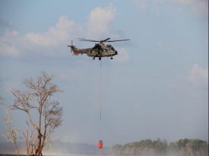
Operation Green Brazil and new technologies were essential to fight the fires in Northern Brazil.
Operation Green Brazil combined military commands linked to public safety organizations, public environmental protection entities, and federal, state, and municipal agencies to fight wildfires in the Amazon. The August 24-October 24 operation yielded the following results: 1,835 fires controlled; $35 million in fines issued against illegal sawmills, illegal loggers, farmers, and people involved in fires or deforestation in the Amazon; 81,000 cubic feet of illegally extracted wood seized; 290 vehicles and vessels confiscated; and 127 people arrested.
To achieve these results, the Ministry of Defense used technology from the Amazon Protection System’s Operations and Management Center (CENSIPAM, in Portuguese), which has three regional centers in Manaus, Belém, and Porto Velho, in the states of Amazonas, Pará, and Rondônia, respectively. “CENSIPAM uses data generated by a technological infrastructure with integrated remote sensor subsystems, radars, weather stations, and data collection platforms installed in the Amazon region. Thanks to this equipment, the Amazon Protection System can monitor the region and provide information in nearly real time,” the Brazilian Ministry of Defense’s Communication Office told Diálogo.
Amazônia SAR
Amazônia SAR (Synthetic Aperture Radar), one of CENSIPAM’s main projects, monitors the earth’s surface via satellites. “The SAR technology can capture images of the land even through clouds. This way, during the rainy season in the Amazon, which lasts about eight months, the radar can process images of the land and monitor deforestation. The information gathered creates deforestation warnings that are submitted to the environmental control agencies,” said the Ministry of Defense.
CENSIPAM also develops the Hydrometeorological Monitoring and Warning System that generates reports and warnings on heat outbreaks for the teams working on Operation Green Brazil. According to the Ministry of Defense, by early 2020, two antennas will be installed in Manaus and Formosa, in Goiás state, with a range that reaches the entire Amazon biome and territorial sea, providing information directly from domestic and international satellites.
Eagle Eyes
A recently developed application, Eagle Eyes, is another important tool and a communication platform between partner agencies that receives information on illegal activities in the Amazon, such as illegal mining, illegal landing strips, deforestation, and fire outbreaks. CENSIPAM developed the new application, which works in a simply and rapid manner.
For instance, a user can photograph a fire and insert various observations, such as the intensity of the fire. The geographic location is obtained automatically, from the GPS on the user’s cell phone or tablet. Since most fire outbreaks in the Amazon happen in areas with no internet connectivity, the application stores all information gathered in the local database. When the device finds an area with connectivity, it synchronizes the information with CENSIPAM’s database. Field agents can then determine the information they want to access.
“The application has been widely used by the Armed Forces and members of government agencies across the Amazon. Agents use the tool during reconnaissance flights or ground missions,” the Ministry of Defense stated. Information gathered by the application facilitates the planning of field operations and decision-making by mission command. Additionally, CENSIPAM can use the information at a later date to validate and calibrate the data received from satellites.